Land Use College will help residents understand Lincolnia planning study
 |
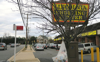
| N. Chambliss Street in Lincolnia. |
Local residents are invited to the first of three Land Use College sessions tonight in preparation for Phase 2 of Fairfax County’s Lincolnia Study.
The sessions will give residents a review of the planning process and how citizens can have input, says Faheem Darab, a senior planner with the Department of Planning and Zoning. Anyone interested in land use issues can attend; it’s not just for people who live in Lincolnia.
The Oct. 25 meeting, 7-9 p.m., in the Holmes Middle School cafeteria, will focus on comprehensive planning. The next session, Nov. 16, will cover transportation, parks, and public facilities planning. A third session, probably in mid-December, will be on processes for implementing plans, including zoning and the capital improvement program.
The Land Use College will help residents understand:
- Who decides what gets built where?
- What can we do about traffic and housing costs?
- Why is development happening in some areas but not others?
- How can I shape my neighborhood’s future?
The first phase of the Lincolnia study, completed in 2015, consisted of a review of existing conditions and editorial changes in the county’s Comprehensive Plan, such the deletion of a reference to a building that no longer exists.
Phase 2, which could result in substantive changes, will begin in early 2017, so “the time is right to prepare folks in the Lincolnia area and Mason District to have input in that process,” Darab says.
Mason Supervisor Penny Gross plans to form a community task force – consisting of a mix of Lincolnia residents and landowners – to make recommendations to the county.
One issue that will be looked at is whether to establish a community business center at the intersection of Route 236 (Little River Turnpike) and N. Beauregard Street, Darab says. That area is plagued by traffic congestion and it’s hard to get in and out of retail areas.
Several years ago, a full interchange plan was proposed for that intersection; now a different solution might work better, he says.
Phase 2 will consider the impact of various changes in the area, including the proposal for hot lanes on Interstate 395 which could lead to new ramps, the City of Alexandria’s proposal for a bus rapid transit line, and the redevelopment of Landmark Mall – all of which would have a spillover impact on Lincolnia.
At 2,000 acres, Lincolnia is bigger than Tysons. The study area is bordered by the Alexandria border, Lincolnia Road, Old Columbia Pike, Braddock Road, Little River Turnpike, Turkeycock Run Stream Valley, and I-395.
According to Darab, phase 2 should be completed by 2019. The task force will start meeting in January. After the community business center issue is resolved, the next step is the development of a land use scenario and analysis – including the impact on parks, schools, transportation, and public facilities – followed by an update of the Comprehensive Plan text.
The final steps will be public hearings at the Planning Commission and Board of Supervisors.


Ellie, thanks for letting us know about these meetings. Do you know whether they are being recorded and can be viewed online?
I did not know about the first session but I did record the one last night and should have it up in a couple of days. The Mason District Council will probably make it available on Youtube.
Thank you. I first learned of the College the very day the initial one took place and only because I read it here. Since that time I have read about it elsewhere. Given the homeless shelter debacle, I very interested in this topic. Also because the govt. is considering making the area around the intersection of Beauregard and 236 a CBC this is very timely. If this area is zoned a commercial busoness center its FAR could increase to 6, which means developers could put a 60,000 sq. ft. building on a 10,000 sq. ft. lot. Without enough infrastructure in place this will make one of the worse areas of congestion in the county even more of a nightmare.
Thank you for the info.
It doesn't matter what they do, as long as its next to the Mason Dump it will remain a dump.
Actually, it looks like the FAR will be 5;1, so just 50,000 sq. Ft on a 10,000 sq. ft. lot.