
Map identifies Annandale property owners in 1860
Do you want to know who owned your land in 1860? Check out this cool interactive map on the Fairfax County History Commission’s website. You might have to play around a bit to find where your home is.
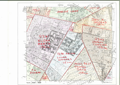
The square labled 71-1 (pictured below) shows the Little River Turnpike/Columbia Pike intersection in the center of Annandale. Most of the land in that area was owned in 1860 by Ambrose Cocke, John Gargas, Stephen Cowling, Elijah Heath, Louisa Summers, and Thomas Crux. The complete set of original Fairfax County in 1860: Property Owners tax maps is available at the Historical Records Room of the Fairfax Circuit Court.
One response to “Map identifies Annandale property owners in 1860”
Leave a reply

I was listening to an historical talk (I think it was re Mosby; it was at the Bleinheim Museum.) It mentioned a place in Annandale, a store of sorts. I am thinking, based on the map in this site, that it was owned by Heath. I am wondering if I could find out more information about the store, did it provide goods to the soldiers in the Civil War? Was it located on or near McWhorter, or where?
Cat Strasburg 703-865-7675